
The City of Hayward – Adapting to Sea Level Rise
City: Hayward
Population: 153,104
Community Story written and posted by BAAQMD, September 2010.
Summary
When the Bay Conservation and Development Commission (BCDC) released a set of maps depicting areas of the San Francisco Bay shoreline vulnerable to sea level rise, the City of Hayward and the Hayward Area Shoreline Planning Agency (HASPA) took notice. HASPA, which consists of the City, the Hayward Area Park and Recreation District, and the East Bay Regional Park District, commissioned a preliminary study to evaluate vulnerable infrastructure, and assess the feasibility of protecting shoreline infrastructure and wetlands along the shoreline.
Program Highlights
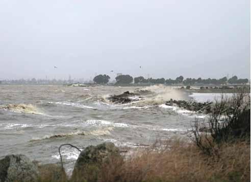
- The Hayward shoreline study was conducted by consulting firm Philip Williams and Associates (PWA) and utilized data from BCDC estimating 16 inch sea level rise by mid-century and 55 inch SLR by 2100.
- The area looked at in the study was the 4.3 miles between Hwy 92 and the San Lorenzo Creek.
- Vulnerable infrastructure in the study area includes storm drainage systems, landfills, utility corridors, wastewater treatment facilities and public access trails.
- A range of options, from trying to maintain the current shoreline configuration or “holding the line”, to enhancing the shoreline’s resilience to sea level rise by restoring tidal ecosystems to a more natural state, are considered in the study.
- Moving forward, HASPA is planning to conduct a more detailed vulnerability study and is currently working to bring additional partners into the process.
Lessons Learned
- A great deal of uncertainty exists about the timing and extent of sea level rise. However, the general trend of accelerated rates of sea level rise is certain.
- Unlike traditional forms of planning that are based on a static landscape, planning for sea level rise requires a flexible approach that can adapt to dynamic shifts in shoreline.
- Past development along the shoreline has reduced some of the shoreline’s natural ability to accommodate sea level rise and has reduced flexibility for potential setbacks or adjustments to the shoreline.
- Future shoreline planning will require difficult decisions about how to best defend vulnerable infrastructure.
Resources to learn more
- The Hayward Area Shoreline Planning Agency (with links to the SLR report as well as staff report to council and ppt presentation)
- BCDC’s Climate Change Page (with annotated links to adaptation studies and resources)
The Rest of the Story…
The “Preliminary Study of the Effect of Sea Level Rise on the Resources of the Hayward Shoreline”, released in March 2010, came about at the urging of Hayward City Councilmember Bill Quirk who also sits on the Board of HASPA. The report itself is the beginning of HASPA’s adaptation efforts. The City’s Climate Action Plan (CAP), which was released before the shoreline study, also calls for the development of an adaptation strategy. Recommendations from the completed shoreline study will be incorporated into future versions of the CAP.
In order to conduct the preliminary study, the three agencies
that make up HASPA each contributed $10,000 to hire a consulting
firm to complete the work. The area of shoreline looked at in the
study covers 4.3 miles extending from north of Hwy 92 to San
Leandro, which primarily consists of tidal marshland mixed with
various manmade infrastructure. In addition to residential and
commercial properties, the study area is also home to
recreational trails, wastewater treatment facilities, railroads,
landfills, high pressure gas lines and other services that could
be disrupted by sea level rise.
The study provides a preliminary assessment of the area’s
vulnerability to predicted sea level rise of 16 inches by 2050
and 55 inches by 2100. Sea level rise projections were based on
data and maps from the BCDC. The study also includes a detailed
appendix comparing various SLR projections and their appropriate
interpretations.
In addition to the vulnerability assessment, the report presents an overview of various approaches for mitigating the expected rise in sea level. Options range from actual armored defense of the shoreline to re-establishing natural systems to allow the marshland to adapt on its own. For example, freshwater from the wastewater treatment system that is currently being piped out into the bay could be re-directed to the marshes, creating brackish water that would allow for faster growth of tidal plants and potentially greater natural resilience.
The likely course will probably be a mix of approaches that will allow portions of the shoreline to adapt naturally. In addition, while the Hayward study provides insight on how various approaches will work to address future sea level rise, these approaches are relatively new and may conflict with commonly accepted best practices and regulations. Moving forward will require extensive discussion and cooperation among the many stakeholders.
The City of Hayward and HASPA’s immediate next steps include continuing to publicize the results of the current study and bringing on additional partners. To that end, HASPA has been presenting the results of their study at various venues and is circulating a resolution of cooperation to mitigate sea level rise to potential new stakeholders.